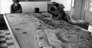
The large amount of data we have collected from the situation maps and War Diaries will be viewable as unit positions on top of the basemaps.
How well do you know the Battle of Normandy? If you read about places like Authie, Buron, or St. Lambert-sur-Dives, would you know where they were without a map? Would you know what operations took place in those towns or which Canadian units fought there?
The five beach landings and the three airborne drops are well known, but when the beaches were secure, the soldiers didn’t just pack up and go back to England.
As Churchill once famously said “This is not the end, it is not even the beginning of the end, but it is perhaps the end of the beginning”.


Caen was the objective of the British Second Army, and subsequently the objective of the 3rd Canadian Infantry Division. It was meant to be taken on D-Day but proved too ambitious of a goal for the British 3rd Infantry Division, forcing the British and Canadians to attempt to hold and fight through a myriad of small towns along the way.

What is Project ’44:
Project ’44 is an online commemoration project set to launch this summer for the 75th anniversary of the D-Day landings. Our website will combine basemaps, unit positions, and war diaries into an online experience focused on the First Canadian Army and the Victory Campaign.

This is a massive undertaking that has taken our team of four, and volunteers over a year to accomplish. To reach this point we have spent months meticulously collecting data on where units were fighting day-by-day in Normandy. This is the most comprehensive database of unit positions ever created.
Allied Divisions: Allied units at the divisional level were collected using the Twelfth Army Group Situation Maps from the Library of Congress. 86 maps from the 6th of June to the 31st of August were Geo-Referenced allowing every unit position to be recorded into a geographical database and catalogued by name, unit type, size, and country. Axis unit positions were also collected and will provide insight as to the effectiveness of Allied intelligence when compared to the known Axis positions.
Axis Divisions: Axis units at the divisional level were collected using German Situation Maps of the Western Front, as well as maps at the scale of 1:200,000 and 1:50,000 of the Caen area. The same meticulous collection process was used as the Allied maps, along with the Axis assumptions on Allied positions.

Units of the First Canadian Army were collected from their respective unit’s War Diary. By using the War Diaries, the team can collect at the Brigade and Battalion/Regimental level of detail. Each position is carefully collected and cataloged with the same pertinent information as above.
Lastly, the positions are checked through a Quality Control process to make sure nothing is mislabelled, mapped to the wrong positions, or given any wrong attribution.
By collecting the unit positions from primary sources and from both the Axis and the Allies, we can get an accurate portrayal of when and where units were positioned. This will allow historians and researchers to conduct analysis on the accuracy of Axis and Allied Signals and Intelligence gathering techniques.
Website
The Project ’44 website will be based on three elements: Basemaps, Unit Positions, and War Diaries.

The foundation of the Project ‘44 website will be the map drawer. This map drawer will allow the user to cycle through an extensive list of maps. There will be original topographic maps of Normandy, aerial imagery from the 1940’s, modern street maps and satellite imagery. These basemaps will serve as the Canvas for the many layers a user can use to create their own experience.
The large amount of data we have collected from the situation maps and War Diaries will be viewable as unit positions on top of the basemaps. A time slider will enable the viewer to move through 87 days of combat and watch the different phases of Operation Overlord. This will allow users to search for any unit by date, and find out when and where they were fighting.

The final piece to the website will be integrating the war diaries of the First Canadian Army. By converting these war diaries into text, we can allow the user to view the daily entries as each unit advances from its point of debarkation all the way until the unit crosses the Seine River.
Combining these three layers we can create an unprecedented historical experience which will have a meaningful impact and allow a better understanding of the Battle of Normandy.

Questions of why it took so long for the British and Canadians to get to Caen will be better explained while viewing this website, or help to better understand why the 4th Canadian Armoured Division was having such a tough time closing the Falaise Gap. If you are reading about the history of Operation Overlord, or about any of the units of the First Canadian Army, this website will put everything you read into immediate context.
Project ’44 will be a place for commemoration, education and research. It will be an easy to use repository of primary source data presented in an engaging way. It will be a place for researchers to go when they are unable to visit the Library and Archives Canada. A place for students to go when they need deeper answers to their questions. A place where Canadians can remember their relatives who fought in the Second World War.
Our lead researcher Drew Hannen has always wanted to know where his Grandfather served in Normandy. Major JD Hannen, was a staff officer for Lt General Crerar’s First Canadian Army Headquarters and would later become the Commanding Officer of the Canadian Grenadier Guards in Montreal. Through our research and mapping Drew was able to follow the footsteps of his Grandfather as the Headquarters of the First Canadian Army swept through Normandy.
But much of our hard work would not be possible without the help of our volunteers. Answering a call to arms in December, a wave of historical enthusiasts joined the ranks of Project ’44 to help with an immensely important task: Converting the War Diaries from PDF to text using Optical Character Recognition (OCR). OCR works well but it still leaves plenty of mistakes to edit.

To help edit the over 2600 pages and over 1,000,000 words within the War Diaries, volunteers were given three specific tasks:
- Correct the text version of the War Diaries to be an exact replica of the original. This means that spelling or grammar mistakes must remain as they are in the original document;
- Format the text document so that each daily entry is in its own row to allow the document to be segmented and easily searched and allow the diary to be converted to HTML; and
- Provide volunteer proof readers for a secondary edit to ensure that Quality Control and authenticity is kept intact.
The War Diaries are incredibly important documents of Canadian Heritage that are often forgotten by the public. These narratives were written every day, and recorded unit positions, daily tasks, casualties and more. These precious documents are short novels in-and-of themselves and are as human in character as the soldiers who wrote them: full of suspense, heartbreak, sadness and humour.

One story in particular came to light when a volunteer shared that his Uncle LCpl pollard was a member of the Stormont, Dundas & Glengarry Highlanders. LCpl Pollard was one of 20 men murdered at the Abbey Ardenne. Through newly acquired documents within the War Diaries we were able to retrace the steps of LCpl Pollard allowing for a better understanding of the Patrol that led to his capture and eventual execution. We will remember them.
Converting the war diaries to text documents from their typed originals, the war diaries will now be accessible to the public in an open and easy to read format. The war diaries will be paired with the unit locations on our web map and will provide a level of context that will stimulate new interest in the Battle of Normandy.
Every day the team is constantly amazed by the outpouring of support for this project. Realizing how much this will affect Canadians spurs us on to dig deeper, to think bolder, and to not stop until we are finished.
Want to know more about the project?
HERE ARE SEVEN FACTS ON PROJECT ’44 MORE SOLID THAN THE HULL ARMOUR OF A TIGER TANK:
- 16,000 mapped unit positions: This includes all RCAF Squadrons who participated in the Battle of Normandy, Force J and the RCN, all positions from the Twenty First Army Group and Twelfth Army Group situation maps, all positions from the Axis Situation Maps and the daily unit positions from the War Diaries of the units of the First Canadian Army.
- 3+ historical map layers: The website will host seamless coverage of the Twelfth Army Situation Maps, 1:100,000 and 1:50,000 GSGS topographic map series to provide historical context. Also included will be never seen before maps and imagery from archives, museums and universities.
- 87 days of combat: Every day of combat will be shown from the day the 1st Canadian Parachute Battalion dropped into Varaville on the 5th of June to when the First Canadian Army raced past the city of Rouen on the 31st of August.
- 70+ War Diaries: Converted from PDF to text documents using Optical Character Recognition.
- 1,260,000 words: Over 1 million words will be converted from the War Diaries to text.
- 6000 pages: Our website will host over 6000 pages of searchable primary sources to include the original war diaries, intelligence reports, map traces and more.
- 40+ Volunteers: We are building a community of volunteers to digitize, map and preserve Canadian Military History and Heritage.
- 100,000 documents: In two years we will be hosting over 100,000 original documents from the First Canadian Army.
Commemoration

Few veterans of the D-Day Landings are still alive while those who are left are well into their 90’s. It is imperative that their memory carries on perpetually. It is our mandate as Canadians to remember. But with so few veterans left from the Second World War, who will carry on their memories?
By bringing these collective stories into a digital database, and displaying it through a website, we not only preserve their memories in perpetuity, but also make them available to new generations of Canadians.
https://youtu.be/TCpKLlUKS3Q
What is the Canadian Research and Mapping Association:
Project ’44 is the first initiative of the Canadian Research and Mapping Association (CRMA). The CRMA is a veteran led not-for-profit corporation with five board members and a team of four staff members. We were inspired while researching maps of the Second World War at the Library and Archives Canada and felt there was a better way to preserve history.
The CRMA is working with key stakeholder organizations from across Canada and has received excellent feedback. Some of our partners, supporters and contributors include:
- The Black Watch of Canada
- The Stormont, Dundas & Glengarry Highlanders
- The Canadian Grenadier Guards
- South Alberta Light Horse
- The Queens Own Rifles of Canada
- Library and Archives Canada
- Garrison Petawawa Museum
- McMaster University
- Juno Beach Centre
- Mapping and Charting Establishment
Beyond Normandy
What is next after Project ‘44? Once our first project is complete, the CRMA will continue into Project ’45 to finish the Victory Campaign as we follow the First Canadian Army into Belgium, Holland and Germany. Our future projects include the Italian Campaign, the Korean War and an exciting initiative called “Project Athena”.
Read another story from us: D-Day Up Close -Dozens of Photos Show the Allies Normandy Invasion
Not only are we experts in mapping military history, we are also leading experts in the digital preservation of maps, documents and photos, and are enabling military museums across Canada to build a digital presence. Through digital preservation, military museums will be able to reach the public in a new and more accessible way.