The Imperial War Museum has revealed Nazi Germany’s reconnaissance maps of the UK from World War Two. The maps are thought to have been found by British soldiers after the D-Day landings in France on June 5th, 1944. The maps have been handed over to the museum after the war that has kept them in their archives until now.
The captured maps show detailed photographs of British towns and cities which the Nazis have used to identify and plot out their aerial bombing raids. However, they also reveal the reason for the inaccuracy of their wartime bombing.

Spies would have taken the pictures from aircraft ahead of the Blitz and then commercial directories obtained by spies operating in Britain would have given them information about what was being produced at each building or site.
Once targets had been identified, the Luftwaffe would then be briefed to target factories and industrial estates during their bombing raids.

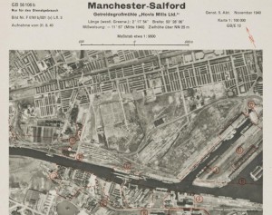
The maps are stored in over 2,000 folders at the museum, and one example shows and highlights the Hovis bread mill. The mill is still standing to this day – it must have been a missed target for the Luftwaffe.
It was the nearby Manchester United football team’s Old Trafford stadium that got the brunt of German bombs intended for the mill. Its pitch was destroyed, and the club had to play at Manchester City’s football ground for the remainder of the war.

Historians at the museum say that the maps include large cities like Manchester, Birmingham, Liverpool and London, as well as smaller towns such as Tunbridge Wells in Kent. They say the captured plans provide vital information about what England looked like before the bombings took place.
The Germans created a series of booklets; you can see one of these document by clicking here