For over one hundred years excavation work has been in progress on an ancient fort that was built on a small peninsula jutting out toward the north near the small town of Burghead in Moray, Scotland. Presently, a Coast Guard station and the town sit on the site. Burghead Fort at over twelve acres was the largest fort in Scotland during the Iron Age.

It was built by the Picts, an early tribe that inhabited the area sometime between the fourth and seventh centuries AD. In 1793 General William Roy made a detailed drawing of the remains of the fort which showed it was divided into two parts; a large area and a smaller raised area where, presumably, the tribal leaders lived.

Because of the size of the fort, it is believed to have been a major stronghold in medieval Scotland and perhaps a center of Pictish society. The website for the visitor center of Burghead has several drawings of what the fort may have looked like.

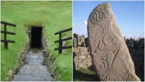
Most of what General Roy drew was destroyed when the town and seaport were updated in the early 1800s, but thirty symbol stones of intricately drawn bulls were uncovered.
As there were no written records regarding the fort or its inhabitants, the stones, of which only six still remain, are all that remains that depict the fort’s grandeur. It is believed that the Picts saw the bull as a symbol of strength and the stones may have been prominent decorations of the fort’s gate.

The only other references to the fort were found in the 13thcentury Nordic history HistoriaNorvegiaea and a volume written by the Roman writer Eumenius in 297 AD. He referred to the people as Picts, originally thought to be from the fact that they painted their bodies with dye, but more recent scholarship claims the people called themselves “Pecht”, meaning “the ancestors”.

Since 2015 an archaeology team from the University of Aberdeen led by Dr. Gordon Noble has been excavating the site. Early on, the team found a fragment of a 9th-century Anglo-Saxon coin.
They recently found the remains of an almost twenty-foot high wall made of oak timbers which normally would have rotted away but when the Vikings set fire to the fort in the 10th century the charring of the wood preserved it.

According to Dr. Noble, the team originally thought they wouldn’t find much of significant value but were pleasantly surprised to find the wall remnants in such good shape.
Using the work of archaeologist Hugh Young, written in the 1800s, the team was able to identify the foundations of the walls.
They also unearthed many bones and shells which may reveal the type of diet the Picts enjoyed. Archeologist Cathy MacIver was able to find three surprisingly small artifacts – two hair or dress pins made of bone, one decorated with cross-hatching and one with a mace head. MacIver also found a copper alloy finger ring.

The Picts are believed to have originated in Scandinavia and migrated to the Scottish Isle as a group of tribes. According to Dr. Noble, “All evidence points to the Picts being indigenous to northern Scotland…they began to coalesce during the late Roman period and formed some of the most powerful kingdoms in northern Britain in the early medieval period”.
They coexisted peacefully for the most part, but when threatened by invasion they joined together against their enemies as when the Romans invaded in 80 BC. The Romans won the battle at Mons Graupius but were unable to conquer the rest of Northern Scotland because of the type of guerilla warfare employed by the Picts.
With no large cities to plunder and no lands to burn the Romans gradually worked their way away from Northern Scotland and the lands of the “Barbarians”.

In about 314 AD Christian missionaries began to move into the area, and by 597 most of the Picts had converted to Christianity. Because of Viking invasions in the 800s, the peoples of Northern Scotland came together and formed a new political entity referred to as Alba which in time became modern Scotland.
DNA studies have revealed that over ten percent of the men in Scotland carry the Y chromosome of the Picts showing the influence these Northern tribes had over early Scotland.