A recent paper, “Assessment and Significance of a World War II battle site: recording the USS Emmons using a High‐Resolution DEM combining Multibeam Bathymetry and SfM Photogrammetry”, published in the Wiley Online Library, has raised some interesting questions regarding the survey and maintenance of our heritage in terms of archaeological remains that are located under the sea.
The USS Emmons was a US Navy Livermore-class destroyer, and minesweeper. Along with the USS Rodman, the two ships set course for Okinawa in WWII. The action report from the Emmons states that it was on radar duty off the north-west coast of Okinawa, tasked with locating and identifying all aircraft near the island.

On 6th April 1945, the two vessels were subject to a kamikaze attack by the Japanese Airforce. In the mid-afternoon, the Rodman was hit by one plane, and the Emmons immediately began to circle the Rodman to provide what protection it could. The Emmons shot down six planes, but was then attacked by five aircraft simultaneously; all five planes hit their target, disabling the ship.

By early evening, it was apparent that the Emmons was no longer operable and the wounded were transferred to another vessel. Later on, there was a massive explosion, and the Emmons was abandoned. Next morning it was deliberately sunk to avoid it being captured by the Japanese.
Nothing further was heard of the wreck until August 2000 when fishermen reported the presence of an oil slick on the sea just north of the Motobu Peninsula. Investigations found the wreckage of a ship, but it was not until 2001 that divers reported that wreck to be the USS Emmons.

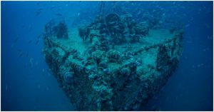
A team of Japanese scientists comprising Hironobu Kan, Chiaki Katagiri, Yumiko Nakanishi, Shin Yoshizaki, Masayuki Nagao, and Rintaro Ono, investigated the wreck of the USS Emmons which was lying in 40 meters of water off Okinawa Island.
The team writes that there are many accounts of WWII from eye-witnesses, but even after 70 years, there is still little material evidence of what happened and even less understanding of how to preserve naval relics for posterity. Pearl Harbor is one of the very few sites that has been extensively surveyed and subject to archaeological investigation.

The UNESCO Convention on the Protection of the Underwater Cultural Heritage (2001) will cover WWII Naval Wrecks from 2039, but at this time there is no policy in place on how to survey, investigate, preserve, and protect these cultural sites.
The study undertaken by the Japanese team aimed to devise a methodology for the precise geographic information that can be used for the preservation, research, and future use of the historically important naval battles that took place off Okinawa Island during WWII.
The team realized that it is simple to build a relief map of WWII battle locations on land and it is easy to survey the area and aerial photography provides most of the data required. However, underwater there is no simple process. The team started by surveying the sea floor using a multi-beam echo sounder. This produced a topographical map of the oceanographic, geomorphological, and sedimentological conditions around the wreck.

Once the team understood the make-up of the sea floor and the ocean conditions around the wreck, they turned their attention to creating a detailed image of the wreck in its current location. They employed their own methodology that used structure-from-motion photo-grammetry and multi-beam bathymetry.
Using sophisticated echo sounders as well as highly technical and advanced software that is able to infer a three-dimensional object from a two-dimensional image, they managed to produce very detailed and sophisticated data about the wreck and its surroundings. The research data gives an extremely accurate picture of the current state of the wreck. The high-resolution plan of the wreck site provides a great baseline for future investigation and study.
The Emmons lies in a roughly north-south orientation, in around 40 meters of water, on a coral reef. The damage caused by the attack is clearly visible, as is the topography of the ocean floor around the wreck. The data collected shows that, since it sank, the wreck has not moved, even though there are strong currents in the area.

One of the issues that needs to be resolved is what to do with unexploded ordnance that is still found on underwater sites. The work undertaken on the Emmons, including the high resolution of the imagery and photographs, shows there are four Mark IX depth charges still in their cradles.
The Japanese Coast Guard has placed warning buoys over the site to warn shipping of the potential danger. Exploding the depth charges in place will destroy the wreck, so the dilemma of what to do in these circumstances needs multi-national discussion to ensure that wrecks are made safe but also preserved.
Many wrecks are impossible to reach for most people, but there are members of the crew that are still living as well as families of those that lost their lives, who may wish to ‘visit’ the site. The creation of such detailed images of the site would allow the authorities to build a land-based memorial close to the location of the wreck. This memorial would be a place to remember as well as to educate people on the naval battles that took place.

It is crucial that mankind does not forget the brave men who lost their lives on the sea; the creation of such memorials would go a long way to ensuring that this does not happen.