
For decades two super powers of the world locked their horns in a seemingly idiotic and potentially catastrophic tussle, and kept the civilized world on the brink of destruction for a generation. We call that era ‘the cold war’, in which US and Soviet Union compete for dominance on earth and in the space. Fortunately few good things came out of this seemingly useless stand off, including the space technology, medicine, and aviation. There is also no shortage of peculiar and simply idiotic incidents during the cold war committed by both nations.
In the very beginning of the cold war Joseph Stalin had authorized a detailed mapping of the whole of the Soviet Union and adjacent small countries. The aim was to have a broader understanding of the geography of the country in order to make full use of the resources for a better economy. With advancement in aviation it had become much more convenient to map the geography using aerial photographic techniques. During this detailed mapping thousands of professional cartographers and pilots took part in a massive project that cost countless hours of painstaking pattern formation as well as a number of deaths on ground and in the air. This exercise provided the later leaders with an endless supply of experts in detailed mapping field, who were then utilized in a much broader and ambitious plan i.e. to map the Europe and United States.
United States and Europe had some idea of the project but no one knew the actual extent of the work since it was seemingly impossible to get hold of any map from Soviet Union. Parallel to this detailed mapping project there was another rather sinister project carried out by KGB and its affiliates. The project was to constantly produce fake and misguiding maps of the towns and cities of Soviet Union, and then to make them public.
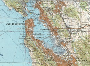
With the fall of the Soviet Union the dark clouds of the Cold war began to disappear, however a number of Soviet secrets started appearing in and around the disintegrating country. One of the most amazing gifts that came out of the Soviet Union’s demise was the finding of Russian maps of US and Europe. These maps were by no mean any ordinary maps; they were more like Google Earth of the cold War. These maps included every minute detail about some of the major cities of Europe and United States. These maps mention the every ‘km’ of the road, structure of every building within a significant area, the number of shops, strength of the bridges, terrain of the area, any potential construction, and so on. This was made possible by extensive efforts of an elaborated and very well coordinated set of spies spread across Europe and United States, the Wired reports.
A number of American companies and some private researches smuggled tons of such maps to United States and United Kingdom. For a while in the early nineties selling Soviet maps to Americans and Brits was a very successful business for some former Soviet officers and government officials. These maps were so elaborated and detailed and above all astonishing that till today there are people who are working on the cartography of Soviet maps and information is still pouring out of such maps day by day.