The Gallipoli peninsula is separated from northern Turkey by the Dardanelles Strait which connects the Aegean Sea with the Sea of Marmara. Perched on the coast of the Sea of Marmara is Istanbul – which was once, as the song goes, Constantinople.
In April 1915, during WWI, the French and the Anzacs (Australian and New Zealand forces) wanted to use the Dardanelles Strait to reach Constantinople, attack it, and push the Ottoman Empire out of the war.
British and French ships had already tried, but underwater mines had impeded them. The army was now joining in and they landed at separate points on the peninsula to tackle the Turkish Army, take control of the area and put a stop to its naval defenses. The Ottoman 5th Army was there to protect Gallipoli.
A lot of what happened at Gallipoli was a series of stalemates and waiting. During one particularly hot week, the Turks and Anzacs were in their trenches staring out at their fallen comrades in the stretch between them known as No Man’s Land. The two sides made an agreement and put down their weapons for a day to bury their dead. Stories are told of the soldiers socializing during this ceasefire, sharing cigarettes, telling stories, and swapping souvenirs.
It finally ended in January 1916. The Ottomans were victorious, although they had the highest casualty rate at 86,000.
The Turkish leader Ataturk had a message for the mothers of the Allied soldiers who had died there:
“You, the mothers, who sent your sons from faraway countries, wipe away your tears; your sons are now lying in our bosom and are in peace. After having lost their lives on this land, they have become our sons as well.”
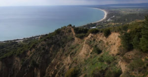
This drone footage takes you over the beaches where the landings took place, through trenches still bedecked in barbed wire, and over the carefully tended graves of soldiers lost at Gallipoli.